Rainfall and rainfall variabiity in Africa by Philip Thornton
The International Food Policy Research Institute (IFPRI) has published an atlas illustrating the current state of African smallholder agriculture.
The Atlas of African Agriculture Research and Development comprises a series of maps and short analyses that showcase and locate the continent’s diverse agricultural challenges and opportunities. Seven topics are covered: political, demographic, and institutional classifications; the footprints of agriculture; growing conditions on the continent; the role of water in African agriculture; drivers of change in African agriculture; access to agricultural trade; and human welfare.
In briefs facing each map, the Atlas answers four questions: What are these maps telling us? Why is this important? What about the underlying data? Where can I learn more? By presenting a broad range of geospatial data and explanatory text, the analysts hope the Atlas will serve as a reliable and up-to-date guide for informed decision-making, which can help speed, broaden and sustain Africa’s agricultural productivity.
Rainfall and Rainfall Variability in Africa by Philip Thornton
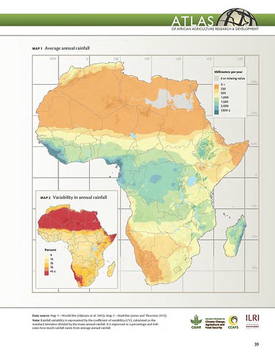
What are these maps telling us?
An average of less than 1,000 millimeters of rain falls per year across most of Africa (Map 1). Rainfall tends to decrease with distance from the equator and is negligible in the Sahara (north of about latitude 16°N), in eastern Somalia, and in the southwest of the continent in Namibia and South Africa. Rainfall is most abundant on the eastern seaboard of Madagascar; portions of the highlands in eastern Africa; large areas of the Congo Basin and central Africa; and parts of coastal western Africa including Liberia, Sierra Leone, and Guinea.
Northern Africa experiences highly variable rainfall, except along the coasts of Algeria and Morocco (Map 2).This region’s coefficient of variation—a measure of how much rainfall varies from the annual average—is greater than 45 percent, reflecting the erratic nature of rainfall in a region that gets little precipitation.
The story is similar in the extreme southwest of the continent and in pockets of the Horn of Africa. The amount of rainfall in parts of the Congo Basin is much less variable, with a coefficient of variation around 10–15 percent. For most of the continent where rainfed crops are prevalent, the variability is 15–35 percent.
Why is this important?
In Africa, where most agriculture is rainfed, crop growth is limited by water availability. Rainfall variability during a growing season generally translates into variability in crop production. While the seasonality of rainfall in the drier rangelands can play a significant role in productivity, rain-use efficiency (RUE)—the amount of biomass produced (in kilograms of dry matter per hectare) per millimeter of rainfall—also drives production.
RUE averages about 3.0 kg of dry matter per hectare for every millimeter of rainfall in northern Africa, 2.7 in the Sahel, and 4.0 in eastern Africa, compared with up to 10.0 or so in temperate rangelands (Le Houérou, Bingham, and Sherbek 1988).
More information
Production of 30-plus maps covering the 7 topics took more than 5 years of work and the collaboration of many experts and organizations, including the Australian Centre for International Agricultural Research (ACIAR) and the UN Food and Agriculture Organization (FAO) on Africa’s diverse farming systems; McGill University on the extent of crop- and pasturelands; HarvestChoice and IFPRI on agroecological zones; and Welt Hunger Hilfe, Concern Worldwide and IFPRI on the severity of hunger.
Scientists at the International Livestock Research Institute (ILRI) produced four of the maps and accompanying analyses:
- ‘Livestock and mixed crop-livestock systems’ and ‘Impacts of climate change on length of growing period’,
by Phil Thornton, of ILRI’s Livestock Systems and Environment Program
and the CGIAR Research Program on Climate Change, Agriculture and Food Security - ‘Ruminant livestock’ and ‘Benefits of trypanosomosis control in the Horn of Africa’,
by Tim Robinson, also of ILRI’s Livestock Systems and Environment Program

Superb post..