Ruminant Livestock Distribution, 2006, by Timothy Robinson, William Wint, Giulia Conchedda, Guiseppina Cinardi and Marius Gilbert.
The International Food Policy Research Institute (IFPRI) has published an atlas illustrating the current state of African smallholder agriculture.
The Atlas of African Agriculture Research and Development comprises a series of maps and short analyses that showcase and locate the continent’s diverse agricultural challenges and opportunities. Seven topics are covered: political, demographic, and institutional classifications; the footprints of agriculture; growing conditions on the continent; the role of water in African agriculture; drivers of change in African agriculture; access to agricultural trade; and human welfare.
In briefs facing each map, the Atlas answers four questions: What are these maps telling us? Why is this important? What about the underlying data? Where can I learn more? By presenting a broad range of geospatial data and explanatory text, the analysts hope the Atlas will serve as a reliable and up-to-date guide for informed decision-making, which can help speed, broaden and sustain Africa’s agricultural productivity.
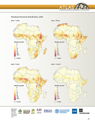
Ruminant livestock distribution in Africa
By Timothy Robinson, William Wint, Giulia Conchedda, Guiseppina Cinardi, and Marius Gilbert
What are these maps telling us?
Ruminant livestock are raised across large parts of Africa where environmental conditions allow. Cattle, sheep, and goats are the most widespread, while camels are restricted to drier areas, particularly in the Horn of Africa and the arid parts of western Africa. These maps of ruminant distribution should, however, be used in conjunction with the livestock production systems map to better understand the systems and climate zones where ruminant livestock are found.
The role of livestock varies greatly depending on the production system. The heavily forested areas and hyperarid deserts of Africa have very low densities of livestock. In arid and semiarid regions of Africa, where the potential for crop growth is limited, cattle, sheep, goats, and camels are raised in low productivity, pastoral (extensive livestock grazing) systems in which ambulatory stock can take advantage of seasonal, patchy vegetation growth. In these areas, raising livestock is the only viable form of agriculture.
In the more settled humid, subhumid, and tropical highland areas, cattle and small ruminants largely live in the same areas as the human population. In these mixed crop-livestock farming systems, livestock can increase crop production by providing draft power and manure, and by enhancing labor productivity. At the same time, organic material not suited for human consumption can be converted into high-value food and nonfood products, such as traction, manure, leather, and bone.
Why is this important?
Poverty in Africa remains widespread.One quarter of the world’s estimated 752 million poor livestock keepers live in Africa south of the Sahara (SSA), where more than 85 percent of them live in extreme poverty (Otte et al.2012). Agricultural productivity gains and diversification into high-value products such as livestock are essential ways of raising rural incomes and improving food security in such areas.
For three reasons—the large share of the rural poor who keep livestock, the important contributions livestock can make to sustainable rural development, and the fast-growing demand for livestock products—diversification into livestock and increased livestock productivity must play an integral role in strategies to reduce poverty and increase agricultural productivity.
Progress in poverty reduction will require well-targeted interventions to promote economic growth that the poor can contribute to and from which they can benefit. Livestock maps such as these, along with other information such as poverty and production systems, can contribute significantly to better targeting.
More information
Production of 30-plus maps covering the 7 topics took more than 5 years of work and the collaboration of many experts and organizations, including the Australian Centre for International Agricultural Research (ACIAR) and the UN Food and Agriculture Organization (FAO) on Africa’s diverse farming systems; McGill University on the extent of crop- and pasturelands; HarvestChoice and IFPRI on agroecological zones; and Welt Hunger Hilfe, Concern Worldwide and IFPRI on the severity of hunger.
Scientists at the International Livestock Research Institute (ILRI) produced four of the maps and accompanying analyses:
- ‘Livestock and mixed crop-livestock systems’ and ‘Impacts of climate change on length of growing period’,
by Phil Thornton, of ILRI’s Livestock Systems and Environment Program
and the CGIAR Research Program on Climate Change, Agriculture and Food Security - ‘Ruminant livestock’ and ‘Benefits of trypanosomosis control in the Horn of Africa’,
by Tim Robinson, also of ILRI’s Livestock Systems and Environment Program
