Benefits of Controlling Trypanosomosis in the Horn of Africa, by Timothy Robinson, Giuliano Cecchi, William Wint, Raffaele Mattioli and Alexandra Shaw.
The International Food Policy Research Institute (IFPRI) has published an atlas illustrating the current state of African smallholder agriculture.
The Atlas of African Agriculture Research and Development comprises a series of maps and short analyses that showcase and locate the continent’s diverse agricultural challenges and opportunities. Seven topics are covered: political, demographic, and institutional classifications; the footprints of agriculture; growing conditions on the continent; the role of water in African agriculture; drivers of change in African agriculture; access to agricultural trade; and human welfare.
In briefs facing each map, the Atlas answers four questions: What are these maps telling us? Why is this important? What about the underlying data? Where can I learn more? By presenting a broad range of geospatial data and explanatory text, the analysts hope the Atlas will serve as a reliable and up-to-date guide for informed decision-making, which can help speed, broaden and sustain Africa’s agricultural productivity.
Benefits of Controlling Trypanosomosis in the Horn of Africa
By Timothy Robinson, Giuliano Cecchi, William Wint, Raffaele Mattioli and Alexandra Shaw
What are these maps telling us?
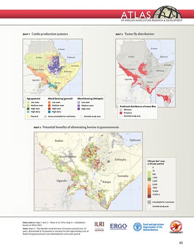
Using the Horn of Africa as an example, the maps illustrate different steps in a methodology developed to estimate and map the economic benefits to livestock keepers of controlling a disease (Shaw et al. 2014). Cattle are first assigned to different production systems as shown in Map 1, illustrating for example, where mixed farming is heavily dependent on the use of draft oxen in Ethiopia, areas of Sudan and South Sudan where oxen use is much lower, and the strictly pastoral areas of Somalia and Kenya.
Information on the location of cattle and production systems is combined with the distribution of tsetse fly species in the area (Map 2) to estimate the presence and absence of trypanosomosis, a parasitic disease transmitted by the tsetse fly. Herd growth and spread is modelled for the current situation, and for the simulated removal of trypanosomosis.
The outputs of the model are then presented as a map of the financial benefits to livestock keepers that would be realized from trypanosomosis removal, expressed as US$ per km2 (Map 3).
The estimated total maximum benefit to livestock keepers, interpreted also as the maximum level of losses avoided, in the Horn of Africa amounts to nearly $2.5 billion, discounted at 10 percent over 20 years to account for the opportunity cost of funds— an average of approximately $3,300 per square kilometer of tsetse-infested area. Map 3 shows how these benefits vary spatially.
Why is this important?
African animal trypanosomosis reduces the productivity of livestock, especially cattle, when it sickens or kills them. It also affects rural development and livelihoods more generally by limiting options for mixed farming and hindering a balanced use of natural resources. Moreover, in many areas the parasite causes sleeping sickness in people; a highly debilitating disease which if not treated is lethal.
Deciding where and how to intervene against this disease requires knowledge of relevant socioeconomic dimensions, such as poverty levels and the role of livestock in people’s livelihoods. The map of potential benefits from trypanosomosis removal in the Horn of Africa can help decisionmakers prioritize interventions by highlighting areas, such as Ethiopia, South Sudan and Kenya, where the financial return on investments to control the disease would be highest.
More information
Production of 30-plus maps covering the 7 topics took more than 5 years of work and the collaboration of many experts and organizations, including the Australian Centre for International Agricultural Research (ACIAR) and the UN Food and Agriculture Organization (FAO) on Africa’s diverse farming systems; McGill University on the extent of crop- and pasturelands; HarvestChoice and IFPRI on agroecological zones; and Welt Hunger Hilfe, Concern Worldwide and IFPRI on the severity of hunger.
Scientists at the International Livestock Research Institute (ILRI) produced four of the maps and accompanying analyses:
- ‘Livestock and mixed crop-livestock systems’ and ‘Impacts of climate change on length of growing period’,
by Phil Thornton, of ILRI’s Livestock Systems and Environment Program
and the CGIAR Research Program on Climate Change, Agriculture and Food Security - ‘Ruminant livestock’ and ‘Benefits of trypanosomosis control in the Horn of Africa’,
by Tim Robinson, also of ILRI’s Livestock Systems and Environment Program
